The Sand Docks: A New Neighborhood for Muskegon
A thriving community like Muskegon needs a variety of housing options for people looking to live, work and stay here.
Located between Lake Michigan and Muskegon Lake, The Sand Docks provides on water and near-water homes that will attract people to the community for year-round and seasonal living.
About
About
Damfino Development, LLC, a Sand Products Corporation (SPC) subsidiary, is the developer of The Sand Docks. The 80 acres was once known as Pigeon Hill. SPC’s first acquisition of property at Pigeon Hill occurred upon the corporation’s formation in 1930 and additional parcels of land were acquired through 1962. The sand on the property was mined for use in the foundry industry until 1967 when mining ceased. The property remained under SPC’s ownership with the intent to develop it at the appropriate time. SPC continued to pay taxes on the land as we waited for the right time to refocus part of our business on creating a new housing development in Muskegon.
We believe the right time is now and we’re investing in, and creating something new and forward thinking for Muskegon.

Brothers Mark and Max McKee began mining sand on the east side of Michigan in the 1920s, and SPC was formed when they merged their company with two West Michigan based mining companies, including the mine operator at Pigeon Hill. The sand from Pigeon Hill was used in making engine castings for the war effort during World War II. The two brothers had 15 children between them and the majority of SPC continues to be owned by the many descendants of Mark and Max.
The CEO of SPC is Max McKee, a West Michigan resident who believes in local investment and working with stakeholders to foster a flourishing community.
Our headquarters was in Detroit for many years, but we relocated to Muskegon in 2011. In recent years the company’s primary focus has shifted from sand mining to marine transportation in the Port City Marine group of companies and real estate development through MiCoast Properties, LLC. Locally the company owns The Mart Dock that handles marine cargo and uses older facilities for seasonal boat and vehicle storage.
Muskegon is Our Home Port
You might not know this, but SPC owns the World War II ship, USS LST 393 located near our offices. For many years it operated as the MV Highway 16, a car transit vessel. Local veterans led by Dan Weikel formed the nonprofit LST 393 Veterans Museum to restore the LST, one of only two LSTs remaining from the 1,051 ships initially built. The museum ship hosts over 10,000 visitors each year from various states and countries.
Port City Cruise Lines, another SPC subsidiary, recently acquired the Port City Princess and now operates the popular Muskegon Lake-Lake Michigan tour boat. The boat was being optioned by an out of town purchaser and would have left the community for good. We’re pleased to have the boat staying in Muskegon as the Aquastar. The name is adapted from a passenger ferry we once owned, the SS Aquarama.
The company is committed to supporting a variety of nonprofits that are working to improve the lives of children and families in the core city of Muskegon.


We’ve been part of Muskegon since 1930 and see great potential here. We’re proud to be helping Muskegon grow and prosper with The Sand Docks.
The Sand Docks

If you’ve ever paddled or cruised past the pilings near the entrance to the Harbour Towne channel or walked the land between Muskegon Lake and Lake Michigan, you already know the appeal of The Sand Docks property.
Close to both lakes, The Sand Docks is a planned community for 240 homes surrounding a newly created 12-acre water feature connected to Muskegon Lake. Because of the location, unique land features and design aspects of the 80-acre tract of land that will be reconfigured for homes, careful planning and permitting requirements with local, state and federal agencies are involved.
Plans
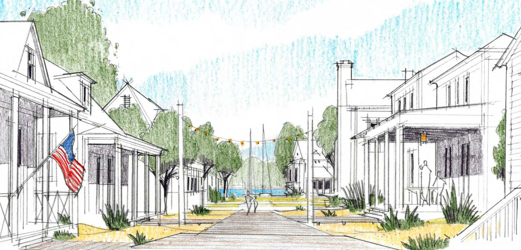
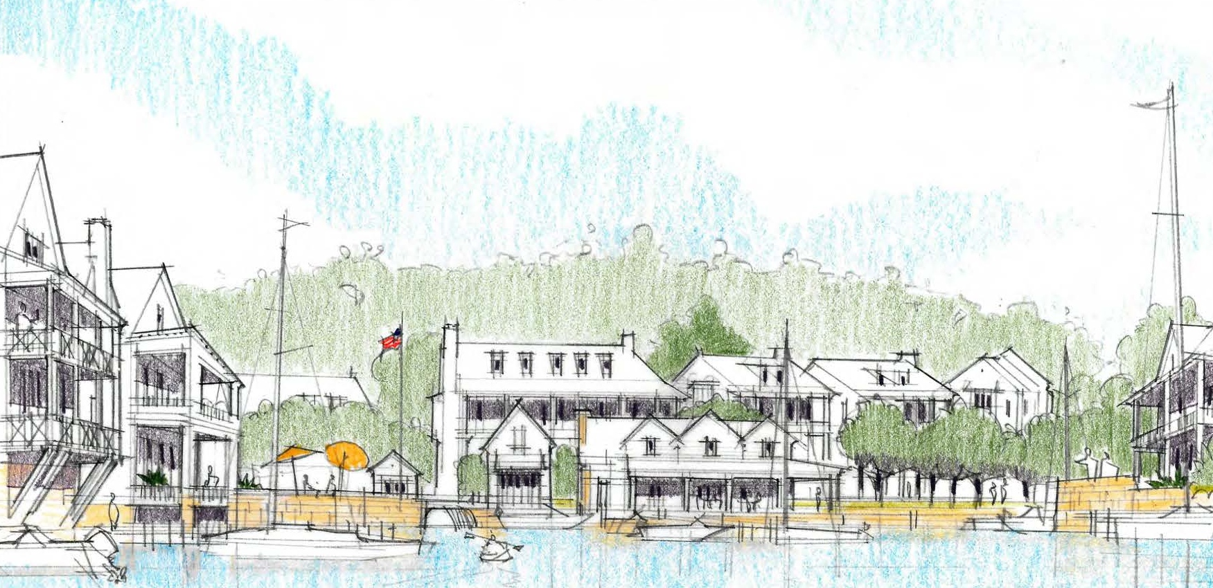
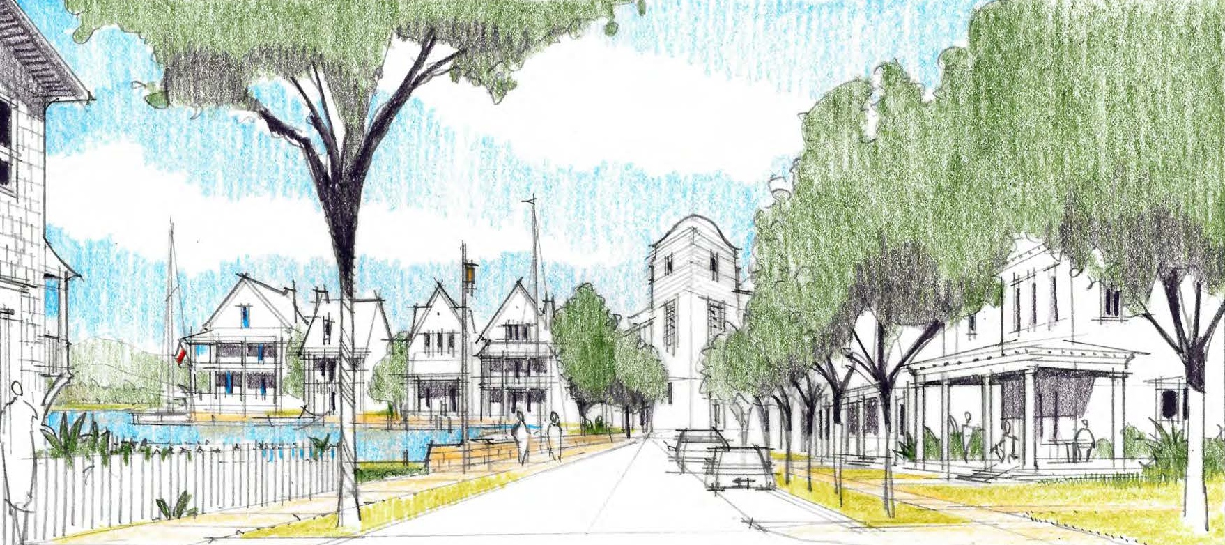
Take a look at the neighborhood we plan to create.
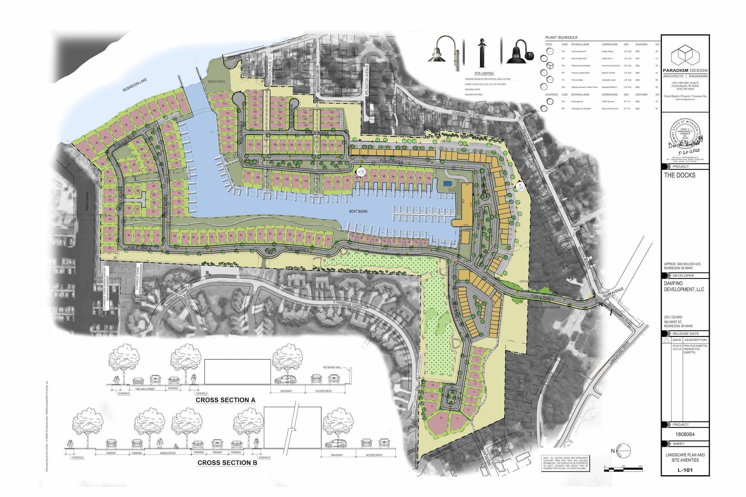
A PUD for the current plan was approved by the City Commission on June 23, 2020.
Highlights include creating a beach near Edgewater Street, keeping the willow tree at the end of the road intact and avoiding proposed connections between The Sand Docks roadways and Edgewater Street or parking at the cul-de-sac.
If you’re not familiar, the purpose of a PUD is to encourage innovation in land use and variety in design. This includes the layout and types of structures including single-family homes that might be attached or detached from another house. PUDs generally have clusters of homes with shared spaces like cul-de-sacs, sidewalks, boardwalk, greenspace or a clubhouse. The Sand Docks will be pedestrian-friendly and open for people to explore.
We believe this kind of development will build a neighborhood that feels a part of the surrounding area and create a sense of place that will attract people to Muskegon.
While you’re on our site, check out a few news stories about The Sand Docks.
From WOODTV8, the Grand Rapids NBC affiliate.
In MiBiz, a West Michigan business publication.
A story on Mlive/Muskegon Chronicle.
From WZZM the ABC affiliate in Grand Rapids.
A story from Grand Rapids Business Journal.
Growing Muskegon
The 240 homes in The Sand Docks will provide much-needed property tax income for the City of Muskegon and the County, too. Schools, the library, museums, veterans and Muskegon Community College will all benefit from having The Sand Docks in the community. Additionally, the City of Muskegon will be able to collect city income tax from the residents who are employed.
When the Sand Docks is fully developed, we expect the total amount of added value to exceed $100 million. Building The Sand Docks will create jobs for local people in construction and interior work. Permanent and seasonal positions will be created within The Sand Docks community itself.


FAQs
Where is the marina basin to be located?
What kind of a traffic study was conducted and when?
Changes to the plan, including a single ingress/egress, reduction in the number of residential units and the addition of a restaurant called for an update to the traffic analysis. Additionally, traffic data collected on August 11, 2018, a peak traffic scenario the afternoon leading up to a Movies on the Beach event, was substituted for the Labor Day weekend data clouded by inclement weather.
The conclusion of the report is that the current site plan for the proposed The Docks PUD generates less traffic than the preliminary PUD (down from 268 trips to 197 trips). Based on the analyses performed in this study, the proposed The Docks development is not anticipated to result in any unacceptable traffic operations under summer Saturday future year (2025) build‐out conditions. No mitigation measures are recommended at any of the three intersections.
You can read the entire traffic narrative here.
Keep in mind that the City has built a traffic circle at the intersection of Beach Street and Lakeshore Drive which has significantly improved traffic flow.
Why can’t the property be left undeveloped?
How can you develop on a critical dune?
The CDA where we have a permit to put a road through will create the only entrance to The Docks. Most of the road project isn’t removing the dune but placing sand on both sides of it to make the slopes more gradual. In this CDA area, we have already removed some trees in the permitted area and will replace them at a ratio of 1.5 trees for each one removed.
In February 2018 the design for the road was made available through the DEQ and the public was able to comment on our proposal.
What about traffic in the area? Is another traffic study going to be done?
Where are the roads in and out?
If you were to walk it now, the main entrance to The Docks might feel steep, but qualified civil engineers designed its grade and width with impact on the Critical Dune Area and traffic safety at the forefront of their work.
How was the density for The Sand Docks determined?
The density is determined by a formula that takes into consideration overall property size, green space and public areas. When approved by the City of Muskegon the proposed PUD for The Sand Docks will have about the same density of houses/residents as the Harbour Towne condominium development.
Will the public be allowed into The Sand Docks?
Yes. The Sand Docks is not a gated or closed community. The streets, sidewalks and boardwalk are open to the public like any other Muskegon neighborhood. Pedestrian access is a priority with sidewalks and boardwalks adjacent to more than half of the waterfront. We’ve included a public beach with approximately 200 feet of shoreline immediately north of the Edgewater cul-de-sac so people can enjoy that part of Muskegon Lake.
Why did you choose a Planned Unit Development (PUD)? What is a PUD?
Had we opted to keep the current R-1 zoning and create a grid neighborhood like Bluffton, we would have been able to have twice as many homes on our property, and that wasn’t our vision. A PUD allows for smaller lot sizes, decreased setbacks, and other variations from R-1 zoning in exchange for innovative design, economical and efficient use of land and the provision of open space.
The housing collections appear compact on paper, but PUD zoning requires provisions for the boardwalks, lawns and other features we want to include. For instance, in our plan, there will be an extensive wetland area and a new 12-acre water feature. R-1 zoning would not have allowed us to build these features into the neighborhood. For both homeowners and visitors, views of and access to Muskegon Lake and Lake Michigan is a priority.
Everything we do with the City of Muskegon and the State of Michigan is part of the public record. We regularly meet and work with City staff in various departments who are helping us refine and modify our plans to be compliant with the City of Muskegon’s standards. The assistance of the City staff has helped move this development forward.
What happens to the wetlands in the area?
What about the deer and other animals on the property?
What is the effect of the development on the water table in the area?
Extensive borings have been made on the property to determine the groundwater level and flow and the text of the report is provided below.
Below is the text of the entire study (May 14, 2019) which was conducted by Lakeshore Environmental, Inc.
Per your request, Lakeshore Environmental, Inc. (LEI), has prepared this document to provide a certification from a professional hydrogeologist that there are no predicted significant effects from the construction of the “Docks” development. This certification is based on the extensive collection and analysis of data specific to this project beginning in March 2018. In addition, LEI staff have completed hydrogeological studies on this site and several adjacent properties since at least 1987. During that time, and in consideration of the proposed method of construction, LEI has identified no data that would indicate the development will result in any negative effects to short or long term groundwater elevations, groundwater quantity, groundwater quality, building foundations, surface water quality, wetland resources, or aquatic resources. A summary of this analysis is provided below.
PERTINENT HYDROGEOLOGICAL CONDITIONS
The surficial geology of the region is primarily characterized by sediments deposited during the later stages of the most recent glacial event, known as the Wisconsinan Glacial Period. At the Docks, the uppermost surficial deposit (where present) is dune sand, which was blown up from the shore of proglacial Lake Nipissing approximately 3,000 to 4,000 years before present. The dune sand is present only in the elevated ridges, above an elevation of 605 feet. As a result, the upper dune sand is dry, and contains no groundwater. Located immediately below the dune sand is approximately 20 feet of lacustrine (lake) sand deposited in Glacial Lake Chicago primarily during the Toleston Stage approximately 11,000 years ago when Lake Chicago was at an elevation of 605 feet. Lacustrine sand is also present from approximately 20 feet to 50 feet below grade that was deposited in Lake Chicago during the Calumet Stage, approximately 12,500 years ago when the lake elevation was 620 feet. The majority of the lacustrine sand is saturated and forms the aquifer at the Docks. As it was deposited in a lake, the sand is clean, well sorted, dense, and relatively consistent in size. It is predictable from a dewatering and drawdown calculation perspective.
A total of 25 soil borings have been completed at the Docks to evaluate site stratigraphy. In addition, 9 observation wells have been installed to evaluate groundwater conditions. The soil borings and observation wells verify stratigraphy is consistent with the geological mode of deposition outlined above. Based on observation well data, groundwater flow is consistent with topography and flows to either Lake Michigan or Muskegon Lake depending on the location within the Docks. At the majority of the property groundwater generally flows to the east or northeast toward Muskegon Lake at a low gradient of 0.00037 (ft/ft). The western portion of the Site flows west toward Lake Michigan at a low gradient of 0.00053. The predicted water elevation for the completed lake will be dependent on the elevation of Muskegon Lake, which has an average elevation of approximately 579 feet. However, since Muskegon Lake is presently above average, the predicted elevation of the constructed upland lake is anticipated to be 580 feet for the next several years.
Based on available information from the Environment, Great Lakes, and Energy (EGLE) GeoWebFace, there are 8 well logs present within a quarter mile of the Docks. A review of these well logs reveals the wells are used for irrigation only and are not potable wells. This is supported by the fact that municipal water is available in the vicinity of the Docks, and connection is required by The City of Muskegon. Although no potable wells have been identified, the nearest shallow irrigation wells were evaluated for potential changes in groundwater elevations as a result of the development. The closest well with an available well log is located at 3223 Park Place (330 feet from the proposed upland lake).
With regard to surface water, the Site is adjacent to Muskegon Lake. At completion, the upland lake will be connected to Muskegon Lake . Lake Michigan is located approximately 2,000 feet west of the proposed upland lake, and the Harbour Towne Marina channel is adjacent to the Docks north property line. The close proximity of these surface waters is the reason the groundwater gradient is very low and it is difficult to change water elevations at adjoining properties.
SHORT TERM CHANGES IN THE GROUNDWATER ELEVATION DURING LAKE CONSTRUCTION
In terms of hydrogeology, short term effects related to lake construction are changes in groundwater elevation due to dewatering and changes in water quality. The water withdrawn from the dewatering process will be discharged directly to Muskegon Lake, in accordance with a surface water discharge permit. Even though all extracted groundwater will become surface water, there will be no actual loss to the regional aquifer due to the large amount of storage provided by Muskegon Lake and Lake Michigan. There will only be a short term lowering of the water table in the immediate vicinity of the project . This lowering will only occur during excavation activities (April through September), and does not occur in the winter, when groundwater levels are anticipated to rapidly equilibrate .
In general, conditions at this location are favorable for dewatering :
- The aquifer has a low transmissivity which results in a narrow cone of depression that does not extend much laterally,
- The Docks is adjacent to several large bodies of water which provide aquifer storage and recharge,
- No residences are located within 300 feet of the dewatering locat ion,
- No potable wells exist in close proximity,
- The upland lake will be constructed with progressive dewatering in at least two smaller phases.
To conservatively predict the effects of dewatering for lake construction LEI utilized groundwater modeling (Visual MODFLOW Pro Version 3.1.0 ). Modeling was completed in accordance with EGLE guidelines. Based on the modeling, during the dewatering for construction of the upland lake, there will be less than 0.5 feet of drawdown at the nearest wells {3223 Park Place and 3434 Pigeon Hill) . Considering the groundwater is more than 1 foot higher than average, and both wells have a minimum of 14 feet of groundwater above the top of the well screens, a drawdown of this magnitude will not cause a loss in pressure, discharge volume, or groundwater quality.
Similarly, no significant changes in the surface water quality are anticipated during construction activities. The dewatering will occur through horizontal (sock) and vertical well screens that transmit clear groundwater in a manner similar to a residential drinking water well. The water will be routed to Muskegon Lake via a splash pad and rock channel.
LONG TERM EFFECTS OF LAKE CONSTRUCTION
Considering the lake will be connected to Muskegon Lake , and there is very little slope to the groundwater due to the proximity of Lake Michigan and Muskegon Lake, there are no significant predicted long term effects of lake construction. Potential long term effects are changes in groundwater elevation from the conversion of groundwater to surface water, changes in groundwater elevations due to increased evaporation, and changes in water quantity and quality.
Even though the groundwater gradient across the location of the upland lake is less than 2 feet, the long term change in groundwater elevation from lake creation and increased evaporation was predicted utilizing groundwater modeling. Based on the modeling, there will be no long term change in the groundwater elevation of the adjacent properties and local irrigation wells. In addition, it is important to note that the creation of the lake will result in a large increase in storage to the shallow aquifer. This storage will significantly reduce seasonal fluctuations, drought conditions, and drawdown created by pumping of the shallow aquifer for irrigation.
Groundwater quality of the aquifer is likely to be improved due to the construction of the lake. Since the proposed lake is a water table lake, iron and hardness are readily removed as the water in the lake is exposed to the atmosphere where it can readily exchange dissolved oxygen and carbon dioxide. This improved lake water is then returned to the aquifer or Muskegon Lake .
CONCLUSION
LEI collected hydrogeological information relating to the proposed lake construction. This included a review of area water wells and geology, local elevation surveys, site soil borings, the installation of observation wells, data analysis, and groundwater modeling to predict the effects of lake construction on area groundwater resources. No short term or long term flooding, drawdown, or changes in water quality are predicted as a result of the proposed upland lake creation for the following reasons:
- All stormwater at the development will be contained within the development and properly managed in accordance with applicable
- No potable water wells have been identified within a distance of 2,000 feet .
- The upland lake is not being excavated through a confining layer or unusual
- The upland lake will be connected to Muskegon Lake and subsequently Lake Michigan. The lake water elevation is not being held up by a dam, pump, or a clay
- The storage and recharge of the aquifer is very high. Dewatering will be localized, with the dewatering discharge to Muskegon Lake (there is no planned discharge to the land surface which creates a potential for flooding).
- Numerous marinas have been constructed in a manner similar to the Docks and in comparable hydrogeological conditions that have not resulted in flooding or a lowering of the
- Any short term or long term reduction of the groundwater elevation due to lake construction is insignificant based on conservative
The Docks is not located within a wellhead protection area, or in proximity to a site of environmental contamination . As a result, the construction of the lake does not have the potential to capture contaminated groundwater. - Construction of the lake requires several permits from EGLE . These permits require an evaluation of the hydrogeological conditions and the proposed effects of lake construction and creation. EGLE completes an extensive review and independent analysis of the data for permit.
As a result of the above analysis , LEI concludes and certifies that the proposed lake construction will not have an adverse effect on area groundwater resources. Thank you for your consideration. Please contact me with any questions, comments, or concerns regarding this information.
When will The Sand Docks work start and be completed?
The steps to develop The Sand Docks are complicated and when we have accurate timetables to share, we will do so. Construction of the entrance road at the intersection of Wilcox and Waterworks and over the dune will begin in October of 2022 and be completed in April of 2023. During this construction phase, pedestrian traffic will be restricted for safety reasons. We are in the process of obtaining all required permits from the City and County of Muskegon, the Michigan Department of Environmental Quality and the United States Army Corps of Engineers that are required to impact the area north of the dune.
© COPYRIGHT 2022 THE SAND DOCKS MUSKEGON. GRAND RAPIDS WEB DESIGN – SIMPLER SITE. ALL RIGHTS RESERVED.